Geokaun Mountain & Cliffs
Valentia Island, Co. Kerry
Geokaun Mountain & Cliffs
Valentia Island, Co. Kerry
Paradise Island of Ireland
Valentia’s highest point and top tourist attraction. Renowned 360º views. All the island can be seen from here. Visitors walk up or drive up on a paved road. Clear views of Blasket Islands, Dingle Peninsula, McGillycuddy’s Reeks, Portmagee, Skellig Rocks. Jaw dropping views of the cliff face and ocean from the viewing deck at Fogher. Encircling the mountain, the magnificent Sky Path (1 mile loop walk) is a slower, more enriching way of savouring those 360º views. Panels of local history give a sense of island life, past and present.
Local tip: Sunrise (if you’re an early bird) and sunset are particularly stunning times to visit Geokaun Mountain & Cliffs.
Highlights
Enjoy superb 360º views of the Blasket Islands, Dingle Peninsula, MacGillycuddy Reeks, Portmagee, The Skellig rocks, and 60 miles to the western Atlantic horizon. NOT TO BE MISSED
Useful Information
- 50 superb information panels
- 4 viewing points at different elevations
- 3 picnic areas
- Parking available at 4 car parks
Getting There
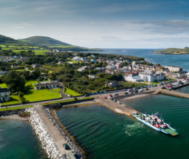
The bridge connects the island to the mainland. And a car & passenger ferry operates from April to September, from Renard Point to Valentia’s fishing village of Knightstown.
Directions from Knightstown village/the car ferry:
1. Exit the car & passenger ferry and turn right
2. Drive up through the village and at the Y-junction take the right road
3. Continue for 2.7km. After the wooded area take a sharp left
4. Then take the next right
5. Continue on this road for 1.7km
6. Geokaun Mountain & Cliffs entrance will be on your right
Directions from Portmagee/the bridge:
1. Cross the bridge and take the next left at the T-junction
2. Continue for 1.5km and take a right
3. Continue for 4km and Geokaun Mountain entrance will be on your left
More
Map Location: 51.917730, -10.350596
Shopping in Kerry